
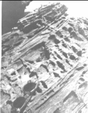
Below, from left to right: close-up of bedrock (glasses for scale)
bedrock and gullies, and a sampling trench (manmade)
|
|
Once the sand overburden is removed, the 'basement' consists of
deep gullies (left) carved by the surf at the time these now raised beaches
were in the surfzone. These gullies are generally perpendicular to the coast and
often have deep potholes in them. Gravels at the bottom
of the gullies and in the potholes are the favorite sites for diamonds,
which are found by the Ovambo mining crew using toothbrushes to do the
final cleanup. Below, from left to right: close-up of bedrock (glasses for scale) bedrock and gullies, and a sampling trench (manmade) |
|

diamond mining |
|

|
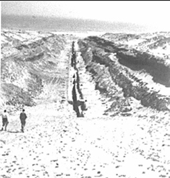
When sealevel remained stable for an extended period, it would
cut seacliffs (left) along the shore. Now, these cliffs
terminate the raised terraces and are
characterized by smooth concave undercuts.
In our offshore geophysical surveys,
we also found buried seacliffs, indicating a complex sequence of
fluctuating sealevels and/or regional uplift. The coast is very rugged, with rocky coves and pocket beaches midway between Oranjemund and Luderitz, and high dunes further north. Because this is 'Sperrgebiet' (off-limits), we caught hundreds of lobsters reaching directly from the longshore rockledges into the cold waters of the Benguela Current |